Summary of Proposed Approach and Structure
-
Economic activity is increasingly concentrated within countries. Across the world, an estimated three quarters of economic production takes place in cities; the more dynamic coastal regions of China produce more than half of the country’s GDP with less than one fifth of its land area; and Greater Tokyo accounts for 40 percent of Japan’s total output on just 4 percent of its land area. In the developing world, this concentration has been accompanied by sizeable—and by some accounts increasing—spatial disparities in living standards and welfare. Per capita income differentials within countries in the developing world tend to be much larger than equivalent differentials within rich countries. Paradoxically, in a world which is rapidly globalizing, one of the most important determinants of well-being is still where a person is born: in which country, in what province within the country, and whether in a city or the countryside within that province.
-
But the location of economic activity in the world is rapidly changing. During the last fifty years, the share of global GDP of today’s rich countries has been about 80 percent. Over the next few decades, projections indicate that this could fall to 40 percent.1 In other words, a substantial portion of the world’s GDP will, spatially, be “in play”, shifting from developed towards developing countries. Which countries, regions and cities will get this will depend to some degree on their natural endowments and their history, and perhaps even on luck. But it will depend much more on the policies that are put in place, because policy reform—at the international, national and sub-national level—can initiate large and lasting changes in economic geography. What can developing countries do to attract a larger share of global economic enterprise, and how can regions and cities within these countries get more of the benefits of this growth?
-
Well documented spatial disparities and the unevenness of growth between and within countries reflect market forces associated with economies of scale and movements of goods and factors, as well as the interplay of competing political interests. Since spatial differences are often also social challenges, two questions arise. The first is whether some people, because of their location, will always benefit much more than others or whether there are inbuilt mechanisms such as movements of labor, capital, and goods that prevent large and persisting differences in welfare across countries, regions, and cities. The second question is whether there is a role for governments to facilitate or ameliorate these responses, to the extent that these adjustments are either not automatic or have large associated welfare costs.
-
The WDR will propose that the concentration of economic activity is inevitable and usually desirable for economic growth, but the large spatial disparities in welfare levels that often accompany this concentration are not. It will propose that the guiding principle for designing policies and institutions that can help developing countries enhance economic concentration while keeping spatial disparities reasonable is better integration of markets. Using the long-term experience of developed and developing countries and the recent advances in economic thinking, the WDR will discuss the approaches and interventions for exploiting the gains from concentration while ensuring that individual well-being does not depend excessively on location.
-
The WDR will present the broad stylized facts, the principal determinants of spatial transformations, and the policy implications of these findings.
-
Three dimensions. The WDR will summarize how the economic topography of the developing world is changing. It will document the increase in density of economic activity, the decline of distance between economic agents and markets, and the persistence of division between and within countries due to natural, cultural and policy-related barriers.
-
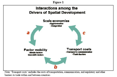
Three determinants. The Report will analyze the determinants of how concentration takes place, by distilling the literature on economic geography for policy-relevant insights. It will illustrate the interplay between scale economies, factor mobility and transport costs by examples from developing and developed countries.
-
Three debates. The Report will complement the analysis of why economic activities are concentrated with an understanding of where they are located by recognizing the influence of natural endowments and political and social institutions. It will inform the debates on the rural-urban transition and territorial development within countries, and regional integration among countries.
-
Figure 1 illustrates how the insights distilled from the literature can be used to inform policies—essentially by determining which of the interactions (denoted as a, b, and c) are most important in shaping each of these transformations.
-
Rural-urban transformation: Scale economies, falling transport costs and factor mobility accelerate the rural-urban transformation. But too much of an “urban bias” in development can lead to high “grime, crime, and time” costs: congestion, slums, and pollution. And with the right policies, rural areas can also benefit from scale economies. Policymakers should aim for progressively deeper integration of rural, peri-urban, and urban factor and goods markets; all three interactions a, b, and c are relevant for effecting a healthy rural-urban transformation of the economy.
-
Territorial development. Many developing countries are seeing widening welfare gaps between leading and lagging regions, partly due to agglomeration economies coupled with falling transport costs. Interactions a and b are especially relevant for exploiting the benefits of concentration while keeping spatial disparities manageable. While policies should aim to improve market links between leading and lagging regions through greater domestic factor mobility especially of that labor, other spatially targeted policies may also be needed.
-
Regional integration. International boundaries still matter, although scale economies and lower transport and communication costs have increased trade opportunities. The greatest divisions remaining in the developing world are often between neighbors. Interaction c may be especially important: regional integration can best help developing countries leverage scale economies and lower transport costs.
Regional initiatives paralleling the WDR will provide more specific policy messages tailored to each regionРІР‚в„ўs circumstances.
-
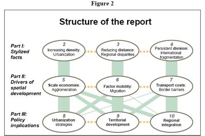
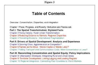
Figure 2 provides a schematic summary of the Report, highlighting the “horizontal” and “vertical” links between the proposed chapters. Part I will provide stylized facts related to the main spatial transformations accompanying development around the world, using density, distance and division as shorthand for the relevant dimensions. Part II will discuss the main drivers of these changes—scale economies, factor mobility, and transport costs—illustrating their interactions using historical and contemporary examples from developing and industrialized countries. Part III will propose policies to improve urbanization processes, territorial development policies, and regional integration initiatives, using a scope that is progressively widened to focus on cities, regions, and countries, respectively. Figure 3 lists the proposed table of contents of the Report.
|


 Related documents
 - 215Kb ~ 1 min (47 pages)